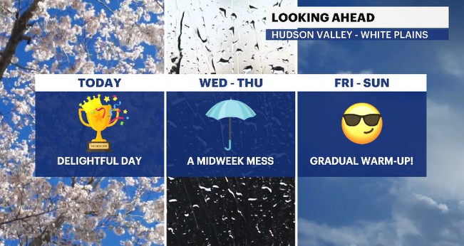
Wall-to-wall sunshine moves in across the Hudson Valley
Enjoy the nice weather while it is here, for there will be clouds and showers coming around soon.
More Stories


Weather Alerts: Westchester and the Hudson Valley
After breaking out the jackets this morning, we'll be grabbing the sunglasses instead later today.
The sun will be shinning nicely all day long as temperatures climb up into the mid-60s. Combine that with a pleasant breeze, and we have the pick of the week today! What won't be so nice, will be the pollen levels across the region. Tree pollen is running very high, and grasses are running at a moderate level.
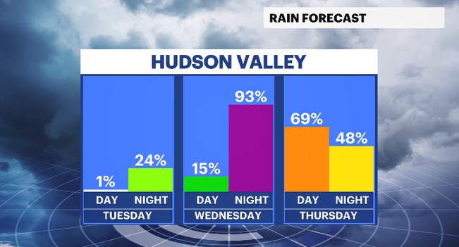
The skies will turn cloudy late tonight, with showers moving in overnight towards Wednesday morning. There will be several rounds of showers coming around for Wednesday with a solid soaking on the way for Thursday. There could be a few isolated, non-severe thunderstorms coming around during this midweek stretch of wet weather. These showers are much needed, as portions of the region are still experiencing a drought.
You can see the timing of the wet weather here:
After the rain moves away, drier conditions return Friday and last through the weekend and beyond! It has been a cool Spring, so far, but things will be changing for the better. Temps this weekend will warm up into the 70s and even 80s for spots by Sunday. We'll build on top of that warmth, that will be around for early next week, as temps attempt to get even warmer! Mid-80s are in sight in the 10 day forecast by Tuesday.
ALMANAC:
Average High: 68 | Average Low: 49
Record High: 86 (1959) | Record Low: 38 (1990)
Sunrise: 5:40 a.m. | Sunset: 8:03 p.m.
THE FORECAST:
TODAY: PICK OF THE WEEK - Sunny and relaxing with temps slightly below average. Highs: mid-60s.
TONIGHT: Clouds increase with spotty showers possible. Lows: mid-40s to low 50s.
WEDNESDAY: Increasing clouds with scattered showers for the second half of the day. Highs: low to mid-60s. Lows: upper 40s to low 50s.
THURSDAY: Mostly cloudy with scattered showers through the day. There is a chance for isolated thunderstorms in the afternoon. Highs: upper 50s to low 60s. Lows: upper 40s.
FRIDAY: Partly sunny and pleasant. Highs: mid-60s. Lows: upper 40s to low 50s.