The heat is on and so is the storm threat heading into the weekend
Heat continues with severe storms that may impact your outdoor plans tomorrow afternoon
More Stories


We didn't quite shatter any records today, but we certainly gave them a run for their money. Highs coasted right into the 90s across parts of the valley this afternoon, and tonight’s going to stay pretty stuffy with lows only dipping into the 60s.
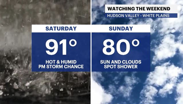
Saturday: Muggy, hot and a bit rowdy
Tomorrow starts out thick. Expect a heavy, muggy feel to the air as temperatures climb right back into the low 90s.
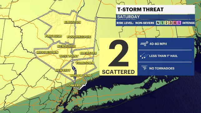
Keep an eye on the sky later in the day, though. We’re facing a threat of strong to severe thunderstorms across the entire Hudson Valley, tracking in after 5 p.m. or 6 p.m. We are currently sitting at a Level 2 out of 5 (Slight Risk) on the threat scale, meaning any storm that decides to break through could pack a punch with damaging wind gusts and some hail.
The Sunday salvage and next week:
The good news? Sunday is looking much more stable. It’ll be noticeably drier, and while temperatures will still trend slightly above average, it won't feel nearly as oppressive as Friday or Saturday. We can't entirely rule out a rogue, stray shower, but the odds are thankfully low.
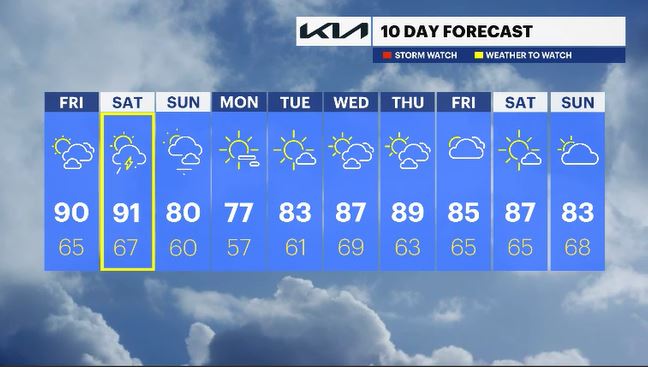
By the time early next week rolls around, Mother Nature finally finds her chill. Expect a beautiful, pleasant stretch of days with temperatures settling right back to where they should be for this time of year.
ALMANAC:
Average High: 75 | Average Low: 56
Record High: 93 (1953) | Record Low: 43 (1990)
Sunrise: 5:23 a.m. | Sunset: 8:24 p.m.
THE FORECAST:
TONIGHT: Partly cloudy with barely a breeze. It may feel stuffy. Lows: low to upper 60s.
SATURDAY: WEATHER TO WATCH - Partly cloudy skies with breezy winds and temps feeling hot and humid. There is a threat of showers and storms after 5 p.m. or 6 p.m. Some could be severe. Highs: Upper 80s to low 90s. Lows: Mid-60s.
SUNDAY: Partly sunny and breezy at times with a spotty shower chance. Highs: Upper 70s to low 80s. Lows: Upper 50s to low 60s.
MONDAY: A few passing clouds with seasonal temps. Highs: Mid-70s. Lows: Upper 50s.
TUESDAY: Mostly sunny. Highs: Low 80s. Lows: Upper 50s to low 60s.