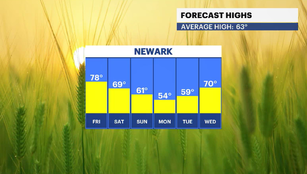
Bright skies and less humidity all weekend before isolated showers Monday morning

NEW: Nice weekend ahead - less humidity, with mostly sunshine and warm temperatures in the mid-80s.
NEXT: Isolated showers for Monday morning, with temperatures set to return to the 90s by midweek.
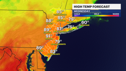
Storm Watch Team Meteorologist Rich Von Ohlen says to enjoy that summer sun this weekend before some isolated showers Monday morning and a return to 90-degree weather by midweek.
TONIGHT: Scattered showers possible after 3 p.m. with higher chances starting at 8 p.m. Best chance of steady rain between 10 p.m. - 3 a.m. Lows down to 71.
TOMORROW: Few morning clouds give way to a sunny and beautiful afternoon! Highs near 87. Lows down to 70.
SUNDAY: More of the same! Plenty of sun and not humid. Late-day clouds. Highs near 86. Lows down to 73. A shower or two possible after 3 a.m.
MONDAY: An isolated shower in the morning, otherwise partly sunny. Highs near 87. Lows around 74.
TUESDAY: Morning sun gives way to afternoon clouds. Hot. Highs near 90. Lows down to 76. Isolated shower or storm can't be ruled out late.
WEDNESDAY: Morning clouds give way to midday sun. Hot. Highs near 91. Lows around 78.
THURSDAY - HEAT ALERT potential: Hazy, hot and humid. Highs near 95. Lows near 80.