More Stories

Last week, NOAA issued its annual winter outlook for the upcoming season.
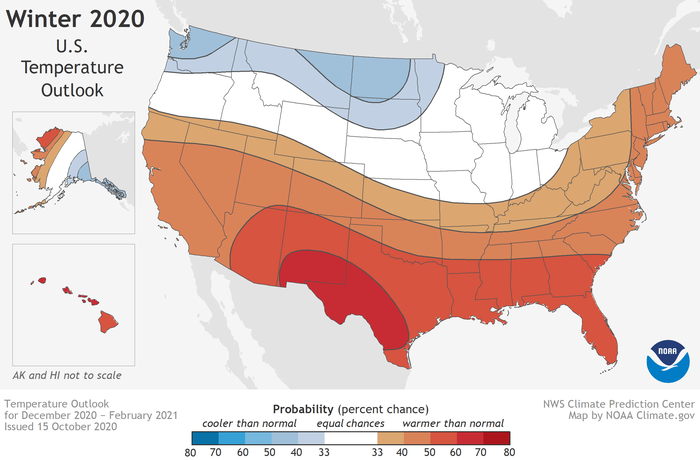
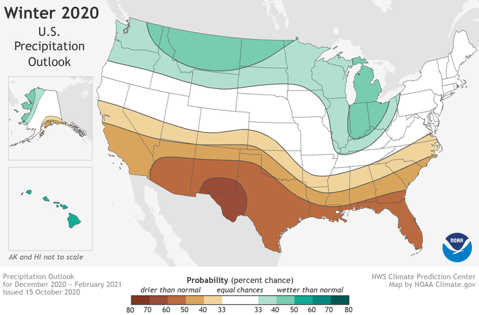
For our area, it calls for generally warmer than average temperatures, and near average precipitation amounts. Their forecast this year was largely based off the continued presence of La Nina conditions in the Pacific Ocean.
 Warmer than normal temperatures are predicted for the southern tier of the U.S., but the Eastern Seaboard is also included in this.
“With La
Nina well established and expected to persist through the upcoming 2020 winter
season, we anticipate the typical, cooler, wetter North[west], and warmer, drier
South, as the most likely outcome of winter weather that the U.S. will
experience this year,” said Mike Halpert, deputy director of NOAA’s Climate
Prediction Center.
 Wetter than normal conditions are expected for much of the Upper Midwest and Pacific Northwest, with dry conditions expected for the southern tier of the U.S.
La Nina is a water temperature anomaly in the Pacific Ocean. Sharp trade winds transport warmer water away from the Americas, allowing colder water to take its place. The colder water is less favorable for the production of storms, which would normally travel north and over the southern U.S. via the jet stream. The lack of storms not only means dry and warmer conditions in the south, but it allows for chillier air and more storms to drop down from Canada into the Northern U.S.
So does this mean that we will only see minute amounts of snow for the second year in a row? Well, not so fast.
There have been a handful of years, several even in this past decade, where we have gotten buried in snow, yet still finished our winter season warmer than average. Sometimes, even in warm patterns, it only takes a few big storms that break perfectly to bring our snow totals up.
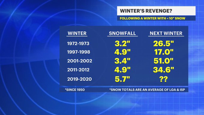
Another thing to consider is history. Over the last 70 years, we have only had a few winters that yielded single-digit snow totals. The following winters have almost always righted the ship.
 Since 1950, our barren winters have almost always been followed up by a return to normal. (These numbers are for Long Island but the numbers are similar for the rest of the Tri-state area.)
Whether or not the winter's precipitation falls as rain, sleet or snow, we could use it. 2020 has been a dry year around here. As of the writing of this article, some spots across the Tri-state are are as much as 5 inches below normal. While parts of our area have gotten marginally better in recent weeks, New England still remains in a serious drought.
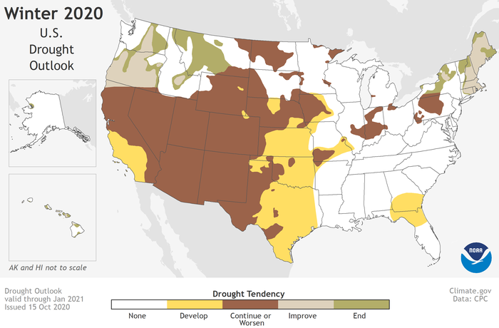
Because of our near normal forecast for precipitation, NOAA does believe that the Northeast as a whole will get better in that department over the course of the winter. Unfortunately, it also believes widespread drought may develop for many of the south and western states.

More from News 12
2:17

Van Nest residents voice concerns over 'road hazard,' ask News 12 for help - again
1:57

Thunderbolt 12: Checking on the slick, wet roads across the Bronx
2:19

Morning rain, mild temperatures Monday in the Bronx
1:53

Record rainfall: The deadly flooding by the numbers
1:43

Tri-state drought monitor for Aug. 14, 2024
1:14
