WIND ALERT: Windy conditions with some sunshine heading into the weekend for Brooklyn
The rain is over but the cleanup is still ongoing after torrential tropical downpours and damaging wind gusts swept through the city yesterday afternoon.
Share:
More Stories
1:27
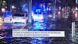
Flooding aftermath in Mott Haven still prevalent less than 24 hours later
2h ago1:53
WIND ALERT: Windy conditions with some sunshine heading into the weekend for The Bronx
5h ago1:48

Major flooding impacts residents on Westchester Avenue
12h ago0:26

Optimum offering free calls, texts from the US to Jamaica due to Hurricane Melissa
yesterday0:20

FAA issues ground delays at tri-state airports
18ds ago1:14

Bronx residents urged to prep for coastal flooding ahead of weekend storm
20ds ago1:27
Flooding aftermath in Mott Haven still prevalent less than 24 hours later
2h ago1:53
WIND ALERT: Windy conditions with some sunshine heading into the weekend for The Bronx
5h ago1:48
Major flooding impacts residents on Westchester Avenue
12h ago0:26
Optimum offering free calls, texts from the US to Jamaica due to Hurricane Melissa
yesterday0:20
FAA issues ground delays at tri-state airports
18ds ago1:14
Bronx residents urged to prep for coastal flooding ahead of weekend storm
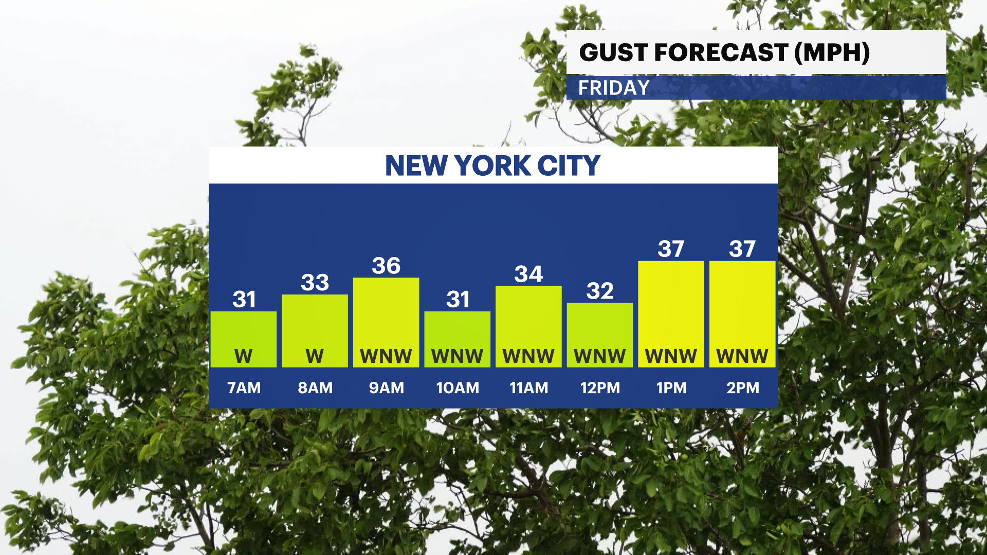
20ds agoA WIND ADVISORY is in effect 12 p.m. today through 12 a.m. on Saturday. Gusts between 40-45 mph expected across the city.

The rain is over but the cleanup is still ongoing after torrential tropical downpours and damaging wind gusts swept through the city yesterday afternoon. It's mostly sunny, cool and windy this morning with wake-up temperatures in the upper 40s to low 50s.
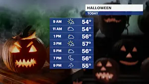
Today will be partly sunny with cool temperatures in the mid-50s. Scary wind gusts up to 40 mph+ is expected through today. Power outages and downed trees are possible again through this evening. Secure Halloween decorations and bring in trash bins. Chilly temperatures in the 50s and gusty winds could make trick-or-treating unpleasant and even hazardous. Stay tuned for any updates.
After receiving 1.5" to 2.5"+ of rainfall in a 24 hour window, drought conditions are expected to improve by next week. Gusty winds stick around through tomorrow with temperatures in the 50s.
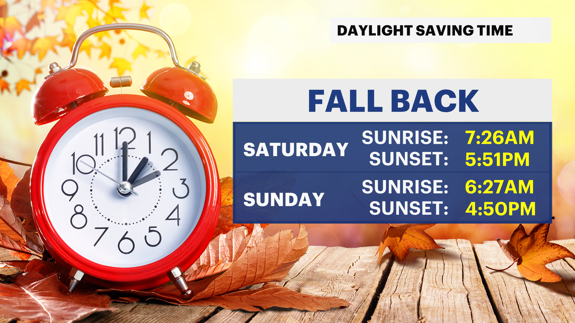
We're switching the clocks back an hour Saturday night. Daylight saving time ends on Nov. 2 at 2 a.m. The sunrise on Sunday will be 6:26 a.m. and the sunset will be 4:50 p.m. The weather looks great on Sunday for the NYC Marathon. The winds subside and the sun will shine bright. There's a chance of rain Monday evening. Election Day looks dry for now. Temperatures will be cool in the 50s with breezy conditions.
TRACKING THE TROPICS: Hurricane Melissa continues to move North as a strong category one hurricane. It currently poses no direct threat to land. Stay tuned for updates!
Today (Halloween): Cool with increasing sunshine. Gusty. Highs near 56.

Tonight: Mostly clear, chilly and still windy. Lows near 46.
Saturday: Sun and clouds, cool with a brisk breeze. Highs near 57. Lows near 44.

Sunday: Mostly sunny and cool. Light winds. Highs near 56. Lows near 45.

Monday: Sun to clouds, cool and breezy. Chance of afternoon rain. Highs near 60. Lows near 47.


Tuesday: Mostly sunny, cool and breezy. Highs near 58. Lows near 45.
Wednesday: Bright and cool. Highs near 56. Lows near 44.
Thursday: Cool with more clouds than sun. Highs near 55. Lows near 44.
More from News 12
1:53
WIND ALERT: Windy conditions with some sunshine heading into the weekend for The Bronx

News 12 weather blog
1:18

Most of The Bronx under extreme heat watch
1:50

Shoppers gear up for winter storm
1:59

'An opportunity to just relax.' Some Brooklyn residents revel in snowfall
2:40
