WIND ALERT FOR A WICKEDLY WINDY HALLOWEEN
In the wake of yesterday's storm, strong winds will flow through the region throughout the day today. Gusts could get up to 40-50 mph. A Wind Advisory is in effect from midday today until tomorrow morning.
Share:
More Stories
1:28

Flooding aftermath in Mott Haven still prevalent less than 24 hours later
2h ago1:53
WIND ALERT: Windy conditions with some sunshine heading into the weekend for The Bronx
2h ago1:48

Major flooding impacts residents on Westchester Avenue
9h ago0:26

Optimum offering free calls, texts from the US to Jamaica due to Hurricane Melissa
yesterday0:20

FAA issues ground delays at tri-state airports
17ds ago1:14

Bronx residents urged to prep for coastal flooding ahead of weekend storm
20ds ago1:28
Flooding aftermath in Mott Haven still prevalent less than 24 hours later
2h ago1:53
WIND ALERT: Windy conditions with some sunshine heading into the weekend for The Bronx
2h ago1:48
Major flooding impacts residents on Westchester Avenue
9h ago0:26
Optimum offering free calls, texts from the US to Jamaica due to Hurricane Melissa
yesterday0:20
FAA issues ground delays at tri-state airports
17ds ago1:14
Bronx residents urged to prep for coastal flooding ahead of weekend storm
20ds agoNATIONAL WEATHER SERVICE ALERTS:
Wind Advisory From 11 a.m. today until 8 a.m. Saturday

For the entire Hudson Valley Sustained west winds of 20-30 mph will be joined along with gusts 40-50 mph
Gusty winds will blow around Halloween decorations and other unsecured objects. Tree limbs could be blown down, and a few power outages may result. Strong winds can also make driving difficult, especially for high profile vehicles. Use extra caution.

WHAT YOU NEED TO KNOW:
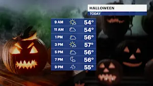
In the wake of yesterday's storm, strong winds will flow through the region throughout the day today. Gusts could get up to 40-50 mph. A Wind Advisory is in effect from midday today until tomorrow morning. Loose objects need to be secured. Halloween plans, such as trick-or-treating, may have to be altered.


Winds linger into Saturday but will not be as high as for today.


Sunday is the nicer of the two days with a light breeze and mostly sunny skies.

Daylight Saving Time ends Sunday morning, where the clocks "fall back" at 2 a.m. and we get an extra hour of sleep.

There will be a few more chances for breezy to windy conditions next week as a few frontal systems move through the region.

There are no large storm systems in sight for next week.
ALMANAC:
Avg. High: 58 | Avg. Low: 41 Record High: 81 (2024) | Record Low: 27 (1988)
Sunrise: 7:25 AM | Sunset: 5:51 PM
10-DAY FORECAST:

TODAY: WIND ALERT - HALLOWEEN - Strong gusts will blow through the region throughout the day. There will be a mix of sun and clouds with a cooler feeling. Highs: low 50s.
TONIGHT: Mostly clear and windy. The winds will make the temps feel chilly. Lows: upper 30s to mid-40s.
SATURDAY: November 1 - A mix of sun and clouds with persistent winds through the day. Highs: mid-50s. Lows: mid-30s.
SUNDAY: DAYLIGHT SAVING TIME ENDS - (CLOCKS "FALL BACK" AT 2 a.m.) - Mostly sunny with less winds around. Highs: mid-50s. Lows: upper 30s to low 40s.
MONDAY: Mostly sunny to mostly cloudy. Highs: upper 50s. Lows: low 40s.
TUESDAY: ELECTION DAY - Partly cloudy and breezy at times. Highs: mid-50s. Lows: upper 30s to low 40s.
WEDNESDAY: Mix of sun and clouds. Highs: upper 50s. Lows: upper 30s to low 40s.
THURSDAY: Partly cloudy and breezy at times. Highs: upper 40s to low 50s. Lows: upper 30s to low 40s.
FRIDAY: Sunny. Highs: low to mid-50s. Lows: upper 30s to low 40s.
SATURDAY: Mostly cloudy with a chance of rain. Highs: upper 50s to low 60s. Lows: mid to upper 40s.
SUNDAY: Mostly cloudy with a chance of rain. Highs: upper 50s to low 60s. Lows: upper 30s to low 40s.

More from News 12
1:53
WIND ALERT: Windy conditions with some sunshine heading into the weekend for The Bronx

News 12 weather blog
1:18

Most of The Bronx under extreme heat watch
1:50

Shoppers gear up for winter storm
1:59

'An opportunity to just relax.' Some Brooklyn residents revel in snowfall
2:40
