STORM WATCH: Chilly and breezy conditions for The Bronx; tracking windswept rain for midweek
A strong storm system will bring rounds of rain and gusty winds to the city Thursday into Friday morning.
Share:
More Stories
0:20

FAA issues ground delays at tri-state airports
14ds ago1:14

Bronx residents urged to prep for coastal flooding ahead of weekend storm
17ds ago0:46

Coastal storm could impact weekend plans in Bronx
19ds ago
News 12 weather blog
24ds ago1:44

Another earthquake in New Jersey rattles NYC
83ds ago
Mayor Adams declares state of emergency due to flash flooding, heavy rain
88ds ago0:20
FAA issues ground delays at tri-state airports
14ds ago1:14
Bronx residents urged to prep for coastal flooding ahead of weekend storm
17ds ago0:46
Coastal storm could impact weekend plans in Bronx
19ds agoNews 12 weather blog
24ds ago1:44
Another earthquake in New Jersey rattles NYC
83ds agoMayor Adams declares state of emergency due to flash flooding, heavy rain
88ds agoHere’s what you need to know:
- A strong storm system will bring rounds of rain and gusty winds to the city Thursday into Friday morning.
- It's another cold start to the day with wake-up temperatures in the low 40s. Wind chills are in the mid to upper 30s.
- Today will be another chilly day with increasing clouds and breezy conditions. Highs are in the mid 50s with gusts up to 25 MPH.
- Clouds build on Wednesday with windy conditions and spotty sprinkles.
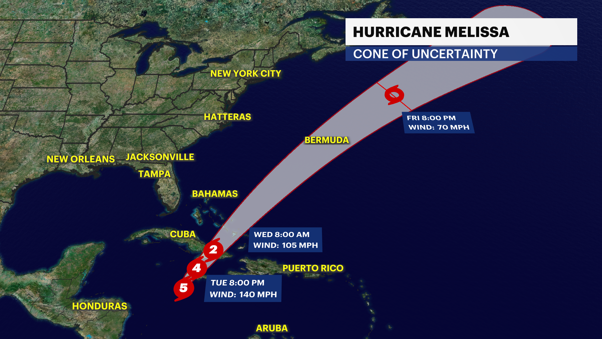
- A strong storm system will approach the city from Southeast to Northeast starting overnight Wednesday through Friday. This storm will bring waves of moderate to heavy rain and a persistent gusty wind through the end of this week. The strongest gusts will be at the coast near 50 MPH. The worst of the storm will be Thursday afternoon and evening when the storm will be closest to the city. This storm system will interact with Hurricane Melissa and enhance how much rain we'll receive. 1 to 3 inches of rainfall is possible through Friday with gusts up to 45 MPH+. The storm pulls away Friday morning, but gusty winds stick around through the weekend. Stay tuned for updates. The rainfall will be beneficial to our ongoing drought. We'll continue to keep you up to date on the latest drought conditions and the impacts in our communities.
- Weather conditions will improve on Saturday as we're welcoming November and switching the clocks back an hour. Daylight saving time ends on November 2 at 2 a.m. Temperatures will be in the 50s with breezy conditions. Clouds pick up on Sunday with a chance of a rain.
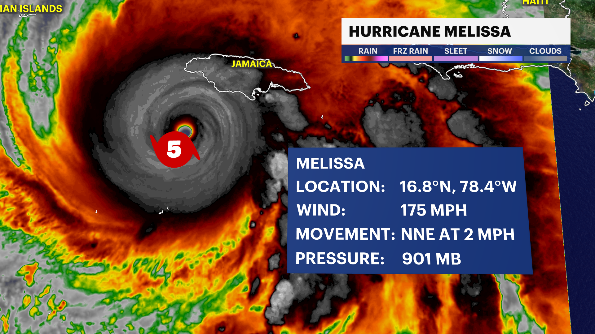
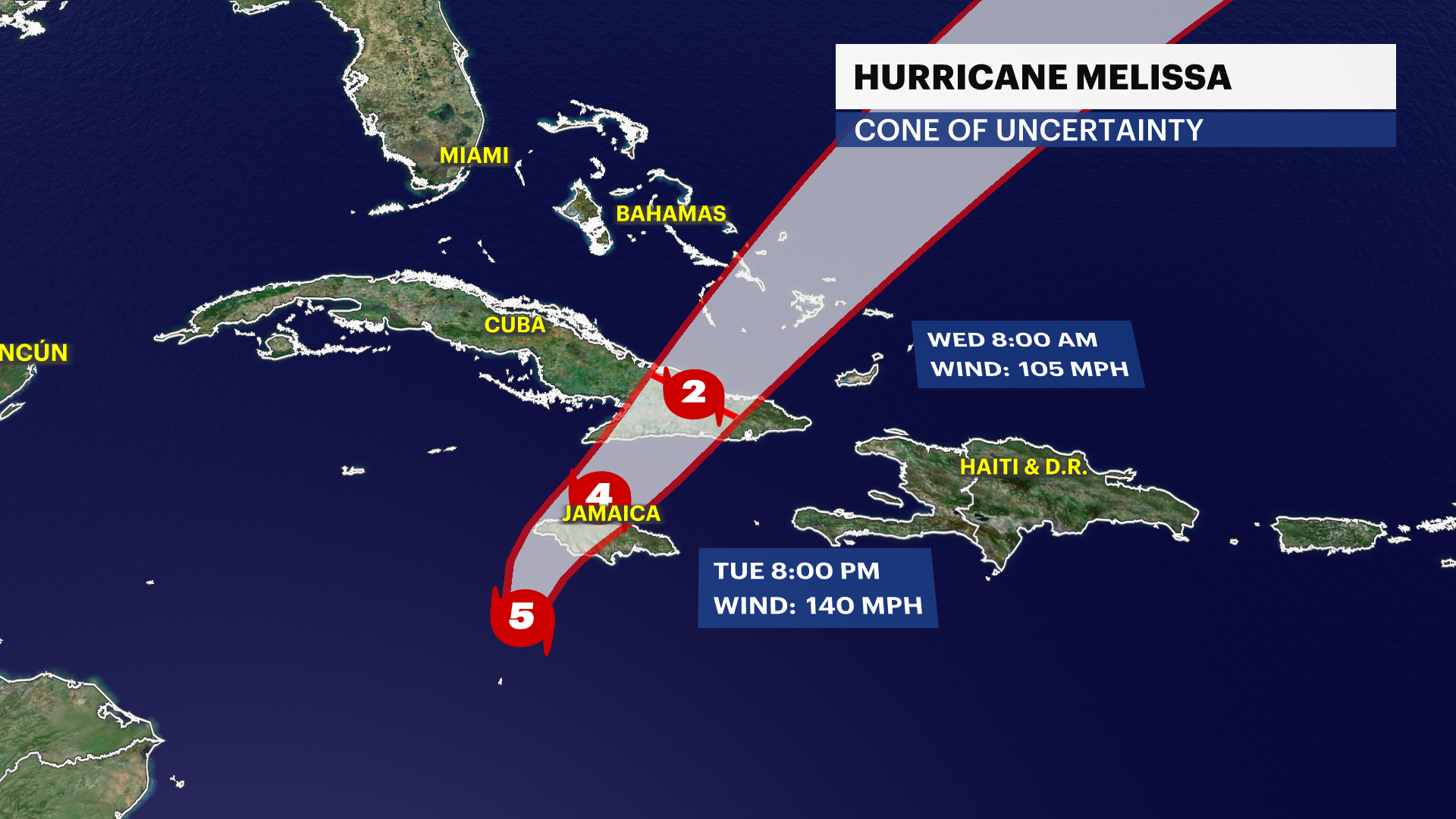
TRACKING THE TROPICS: Hurricane Melissa slowly moves into western Jamaica this morning. It is expected to make landfall later this morning as major category five storm. This will be the first time ever in recorded history a category five hurricane makes landfall in Jamaica. The strongest hurricane to ever hit Jamaica was a category three storm in 1988 (Gilbert). Catastrophic flooding, landslides, destructive winds and significant storm surge will bring power outages and extensive infrastructural damage for weeks. Haiti and the Dominican Republic will continue to face Melissa's wrath as it slowly moves north and wraps around more heavy rainfall and damaging winds to the neighboring islands through this evening. Eastern Cuba, Turks and Caicos and the Bahamas will be the next areas of concern for powerful winds, major flash flooding and life-threatening storm surge on Wednesday. Hurricane Melissa continues its northern path towards Bermuda by the end of this week. Stay tuned for updates!
Today: Sun to clouds, cool and breezy. Highs near 56.

Tonight: Mostly cloudy, cool and breezy. Lows near 47.
Wednesday: Cloudy, cool and breezy. Spotty light rain. Highs near 56. Lows near 48.
Thursday: Wind-driven rain and cool. Highs near 59. Lows near 49.


Friday (Halloween): Chance of morning breezy showers. Still cool with a gradual clearing sky. Gusty. Highs near 58. Lows near 48.

Saturday: Sun and clouds, cool and breezy. Highs near 57. Lows near 46.
Sunday: Partly sunny and cool. Chance of afternoon rain. Highs near 57. Lows near 47.
Monday: Sun to clouds, cool and breezy. Chance of rain. Highs near 55. Lows near 44.
More from News 12
News 12 weather blog
1:18

Most of The Bronx under extreme heat watch
1:50

Shoppers gear up for winter storm
1:59

'An opportunity to just relax.' Some Brooklyn residents revel in snowfall
2:40

STORM WATCH: The outlook for December is stormy. Here is an early look
1:24
