STORM WATCH: Tracking heavy rain and strong gusts for Thursday in Brooklyn
It's still chilly this morning but not as cold as it's been. Wake-up temperatures are in the upper-40s under a overcast sky and a brisk breeze.
Share:
More Stories
2:23

STORM WATCH: Tracking heavy rain and strong gusts for Thursday in The Bronx
1h ago0:20

FAA issues ground delays at tri-state airports
15ds ago1:14

Bronx residents urged to prep for coastal flooding ahead of weekend storm
18ds ago0:46

Coastal storm could impact weekend plans in Bronx
20ds ago
News 12 weather blog
25ds ago1:44

Another earthquake in New Jersey rattles NYC
84ds ago2:23
STORM WATCH: Tracking heavy rain and strong gusts for Thursday in The Bronx
1h ago0:20
FAA issues ground delays at tri-state airports
15ds ago1:14
Bronx residents urged to prep for coastal flooding ahead of weekend storm
18ds ago0:46
Coastal storm could impact weekend plans in Bronx
20ds agoNews 12 weather blog
25ds ago1:44
Another earthquake in New Jersey rattles NYC
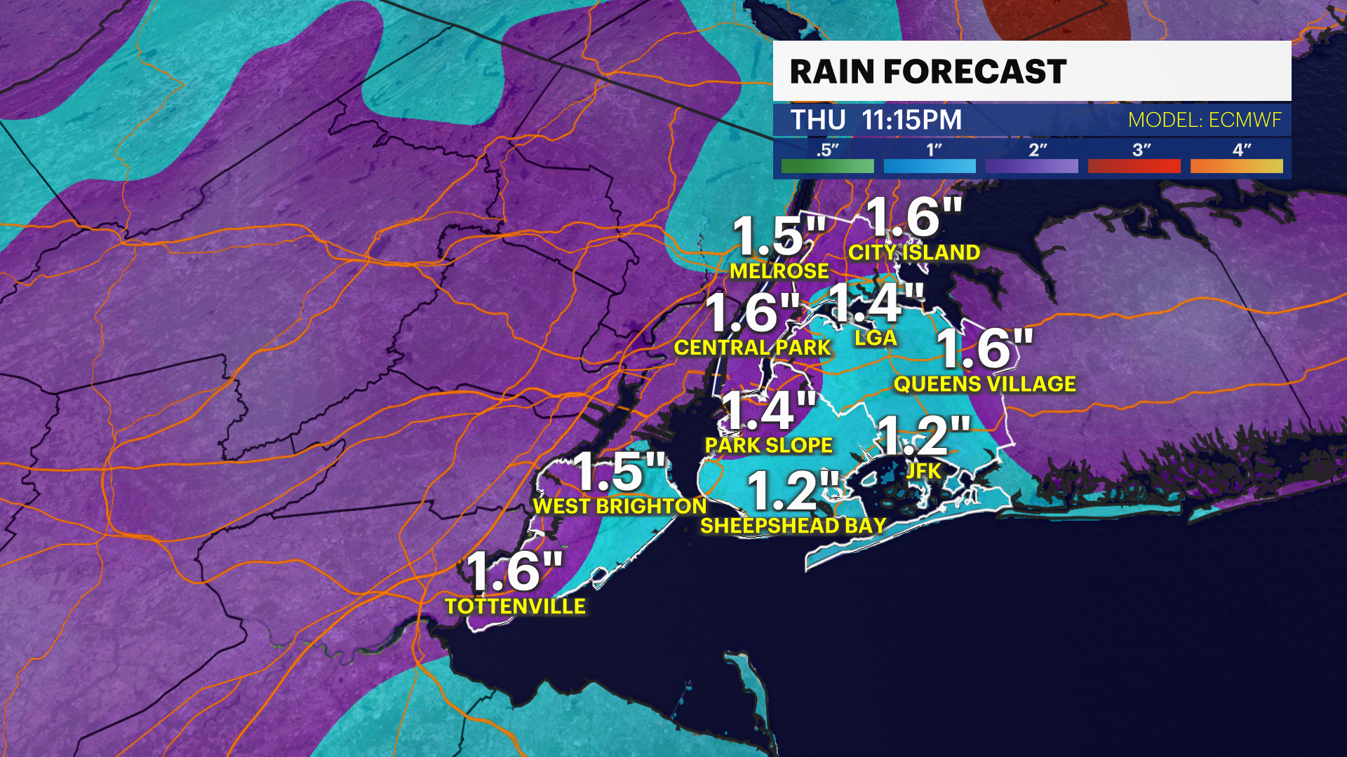
84ds ago- Rounds of moderate to heavy rain and strong gusts will impact the city after 3 a.m. through 10 p.m. on Thursday. Localized flooding and large ponding on the roads are expected in the most vulnerable communities. Strong gusts will knock down tree limbs/trees, powerlines and outdoor holiday decorations.
- It's still chilly this morning but not as cold as it's been. Wake-up temperatures are in the upper-40s under a overcast sky and a brisk breeze.
- Today will be cool, mostly cloudy and breezy with a few sprinkles close to the coast. Highs are in the mid-50s with gusts up to 25 mph.
- Wet and breezy conditions will bring slick travel for the Thursday morning commute. The worst of the storm will be after 1 p.m. - 7 p.m. on Thursday. Windswept rain is expected to bring nasty travel for the afternoon and evening rush. This storm system will interact with Hurricane Melissa and enhance how much rain we'll receive. 1-2" of rainfall is expected through Thursday night with an isolated 3" possible with any downpours. Poor visibility, slippery travel and isolated flooding will impact the Thursday evening commute. Gusts 35 - 45 mph+ will cause isolated power outages across the city. The storm pulls away overnight, but gusty winds stick around through the weekend.
- Halloween will be drier, cool but windy. Gusts up to 40 mph with chilly temperatures in the low-50s could make trick or treating a bit uncomfortable for some.
- We're switching the clocks back an hour Saturday night. Daylight saving time ends on Nov. 2 at 2 a.m. The sunrise on Sunday will be 6:26 a.m. and the sunset will be 4:50 p.m. Temperatures will be in the 50s with breezy conditions. The weather looks great on Sunday for the NYC Marathon. The winds subside and the weather is trending drier. Stay tuned for updates.
TRACKING THE TROPICS: Hurricane Melissa made landfall near New Hope, Jamaica yesterday as a powerful Category 5 hurricane with maximum sustained winds of 185 mph. It continues to move North as it makes a second landfall in the Cuban Province of Santiago de Cuba near the city of Chivirico overnight. Catastrophic flooding, landslides, destructive winds and significant storm surge continues through this morning in Eastern Cuba. Turks and Caicos and the Southeast/Central Bahamas will experience hurricane conditions, major flash flooding and life-threatening storm surge through this evening. Hurricane Melissa continues its northern path near Bermuda on Thursday bringing heavy rainfall. Stay tuned for updates!


Today: Cloudy, cool and breezy. Spotty sprinkles/light rain at the coast. Highs near 55.

Tonight: Overcast, cool and breezy. Late rain. Lows near 50.
Thursday: Wind-driven rain and cool. Highs near 60. Lows near 49.


Friday (Halloween): Cool with increasing sunshine. Gusty. Highs near 58. Lows near 48.
Saturday: Sun and clouds, cool and breezy. Highs near 57. Lows near 46.
Sunday: Mostly sunny and cool. Highs near 55. Lows near 47.

Monday: Sun to clouds, cool and breezy. Highs near 57. Lows near 45.
Tuesday: Partly sunny, cool and breezy. Highs near 56. Lows near 46.
More from News 12
2:23
STORM WATCH: Tracking heavy rain and strong gusts for Thursday in The Bronx
News 12 weather blog
1:18

Most of The Bronx under extreme heat watch
1:50

Shoppers gear up for winter storm
1:59

'An opportunity to just relax.' Some Brooklyn residents revel in snowfall
2:40
